Jacobs partnered with the Environment Agency in England to develop a cloud-based platform that improves forecasting and decision-making during flood events. Read for the full details on this game-changing tool and how data-enabled solutions are shaping climate response.
Flood management is a significant challenge for communities worldwide, particularly as climate change results in more intense, and less predictable, storm events.
Access to high-quality forecast and risk data is essential when responding to flood incidents, although in many cases existing tools cannot provide the required information fast enough – often taking hours or sometimes days to undertake analysis, by which time the flood has already passed.
To help address this challenge in England, the Environment Agency commissioned Jacobs to develop an innovative digital solution that would provide real-time evaluation of flood risk consequences.
The Environment Agency is responsible for managing flood risk across England, taking the lead role in advising the public about flood risk, maintaining flood management infrastructure, and responding to flood incidents. The Environment Agency was looking for real-time insights into how flood incidents will unfold, allowing for better informed decisions and more effective risk communication with the public.
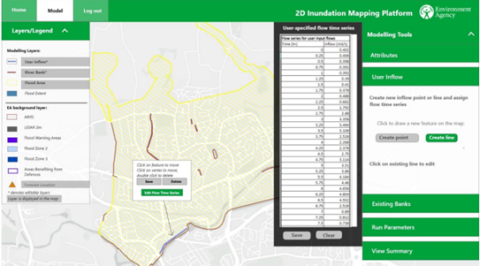
The data-enabled solution that Jacobs developed for the Environment Agency is the Flood Incident Mapper (FIM) tool, which leverages the technology behind Flood Modeller. FIM is a web-based, on-demand 2D hydraulic modelling platform that allows for instant creation of hydraulic models to forecast flood extents associated with failure or overtopping of flood management assets (walls, pumps, gates) during a storm event. At the click of a button, users can create detailed hydraulic models and simulations in a cloud environment. The results are available in minutes and displayed using a webmap for easy interpretation and rapid sharing with stakeholders and the public.
The system also provides instant statistics on asset data, ground elevation models (LiDAR) and existing flood warning areas, which further supports operational decisions. Automated model setup and a cloud-based platform mean that the solution can easily be used by non-technical teams, which is essential during a flood incident.
“We have enabled our highly accurate and robust 2D numerical engines, which undertake the complex mathematical calculations required for flood forecasting, to deliver the results in minutes instead of hours, or sometimes days, which had previously been the case,” says Jacobs Water & Environment Director Richard Crowder. “This game-changing technology will enable decision makers to take timely actions during life-threatening floods.”
FIM will be used by the Environment Agency to support flood forecasting and incident response nationally. Understanding the impacts of asset failures or overtopping will help the agency make on the ground choices about where to commit resources.
“The FIM platform will be a valuable addition to our national flood risk management capabilities and we plan to operationally implement in 2023,” says Tim Harrison, Senior Advisor at the Environment Agency. “We can use the tool to better understand the areas and properties most likely to flood in real time, which can speed up and better target our response to flood events.”
We built the platform to be scalable and adaptable to other purposes. The system uses tools and technologies developed by Jacobs over many years, which will allow for similar solutions to be developed for other clients such as flood risk management authorities in other countries or water utilities managing sewer overflows.
We’re already using the processes behind FIM in support of other solutions developed by Jacobs, including Aqua DNA which uses automated model building and simulation to assess the consequences of water network blockages.
“As climate change creates additional challenges for the global water sector, Digital OneWater solutions such as this flood forecasting tool allow our clients to make better informed decisions and protect the public and the environment during times of crisis,” explains Jacobs Global Water Resources and Resilience Director Adam Hosking. “Data-enabled solutions play an important role in our commitment to climate response.”
You might be interested in...
-
 Solution
Flood Modeller
Flood Modeller is an industry-leading flood modeling software which enables engineers and scientists to deliver faster and more accurate results by simplifying the modelling of river, surface water, and urban drainage systems, and removes the need to use other software.
-
 News
NewsHelping the Environment Agency Deliver its Flood, Coastal Erosion Risk Management Strategy
Jacobs is continuing to support the Environment Agency in implementing its Flood and Coastal Erosion Risk Management (FCERM) Strategy through providing flood and coastal risk management expertise on three key national projects.
-
 Solution
Aqua DNA
Aqua DNA, an intelligent digital solution that collects live data and improves wastewater network performance using smart sensors and AI-powered predictive analytics to reduce risk and make a positive societal and environmental impact.


