


Product
-
Save to favoritesShare with your friends
-

Capturing the highest quality mapping imagery requires a partnership of high-tech tools and industry-leading talent. This is where GeoPodTM thrives, thanks to its potent combination of cutting-edge technology, seamless hardware integration and pioneering software, and the focused recruitment of leading experts and specialists. The result: a proven, integrated system that uniquely enables geographically distributed imagery mapping of the highest grade, accuracy and reliability.
As part of Jacobs’ Aeroptic® product line, GeoPodTM aims to ensure the highest quality data is produced at every stage of image capture through processing. To achieve our goals, including our mantra of making every pixel count, we leverage state-of-the-art components available from the commercial market, and combine this with our expertise on calibration and integration for the airborne environment.
Key benefits
-
Unsurpassed visual data quality
The leading optical assemblies, ratio sensors, direct geo-referencing technology and next-generation Inertial Measurement Unit (IMU) combines with cutting-edge calibration to generate image data of unrivalled quality, leading to highest-grade imagery maps.
-
Superior service at a lower cost
The GeoPodTM system is shown to be 50% less expensive than competing aerial services thanks to its superior collection rate and a vertically integrated, direct geo-referencing processing workflow.
-
Works faster and more accurately
The system has a market-leading processing speed and delivers exceptional geospatial accuracy. For time-sensitive projects, Jacobs delivers completed mosaics within 24 hours of collection, regularly doing so for millions of acres per day.
-
Offers seamless scalability
The GeoPodTM system can be quickly and safely scaled to cover millions of acres with third-party flight service providers and it offers rapid and efficient provisioning of sensor systems anywhere in the world.
-
Durability in all conditions
The rugged, electronic shutter sensor systems ensure reliability and long life in the harshest operating conditions, and its packaging reflects its roots as a military mapping system.
-
Easy transport and portability
The system hardware ships in rugged cases that a single person can easily transport as luggage, and it takes less than 1 hour to install on an aircraft, with no significant aircraft modifications.
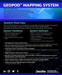
Key features
- Federal Aviation Administration (FAA) approved with a FAA Supplemental Type Certificate (STC) for temporary installation onto commonly available aircraft
- Visual, 3D, and multispectral/thermal configurations, with lidar coming soon
- Intuitive, automated Flight Management System (FMS)
- Cloud-based mission management software (SUMMIT)
- Highest sharpness commercially available optics, ruggedized for long term, metric use
- Global electronic shutter, high dynamic range and superior signal-to-noise ratio sensors
- Fast pilot-operator training