Port of San Francisco Waterfront Resilience Program
Adapting 7.5-miles of the San Francisco Waterfront to be resilient to earthquakes, coastal storms and sea level rise, including the preservation and fortification of the 100-year-old Embarcadero Seawall
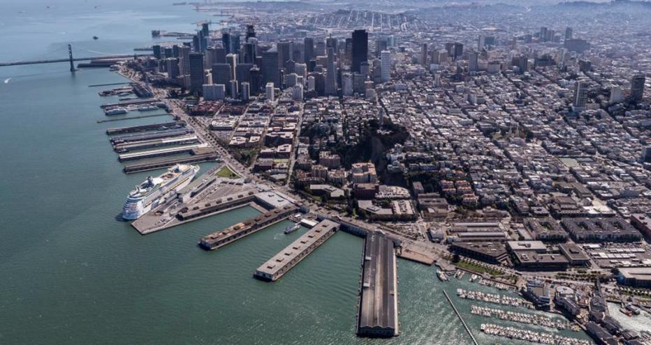
The San Francisco Waterfront is well known for its historical significance. The construction of the Embarcadero Seawall transformed the city into a major trade and financial hub by the end of the 19th century, laying the foundation for a thriving Port of San Francisco (the Port) today.
But the waterfront and the historic seawall beneath the Embarcadero has deteriorated over the past 100 years and is at risk to hazards such as seismic activity, flooding and sea level rise. These immediate and longer-term hazards are being addressed by the Waterfront Resilience Program, a top infrastructure priority for the Port and city.
The Port’s Waterfront Resilience Program allows for the strengthening and adaptation of over seven miles of waterfront including the, more than 3-mile, century-old seawall.
The seawall protects critical regional transportation assets, utilities and over $100 billion in assets and annual economic activity. Time is of the essence as estimates show a 72% chance of a major earthquake happening between now and 2043 and projections of water levels rising more than three and a half feet by 2100.
The Embarcadero’s 100-year-old seawall needs improvements for earthquake safety, near-term flood protection and a plan for long-term resilience and sea level rise adaptation. The first phase of the Seawall Program addresses the most critical life-safety upgrades along the Embarcadero.

Port of San Francisco Waterfront Resilience Program by the numbers
-
72 %
chance of a major earthquake between now and 2043 (U.S. Geological Survey)
-
30 +
firms and numerous agencies working together for success
-
100 +
years old (Embarcadero Seawall age)
-
1.5 +
feet of sea level rise projected by 2100
-
7.5
miles of shoreline in the Port of San Francisco's jurisdiction
-
28 %
of the work delivered by Local Business Enterprises
“The City and County of San Francisco and the Port have taken this challenge head-on with a strong vision and believe in the urgency of strengthening the Seawall and adapting the waterfront over the next 50 plus years. It’s an amazing opportunity to work for a client that has the foresight and fortitude to make a truly meaningful difference to the citizens it serves for many years to come.”
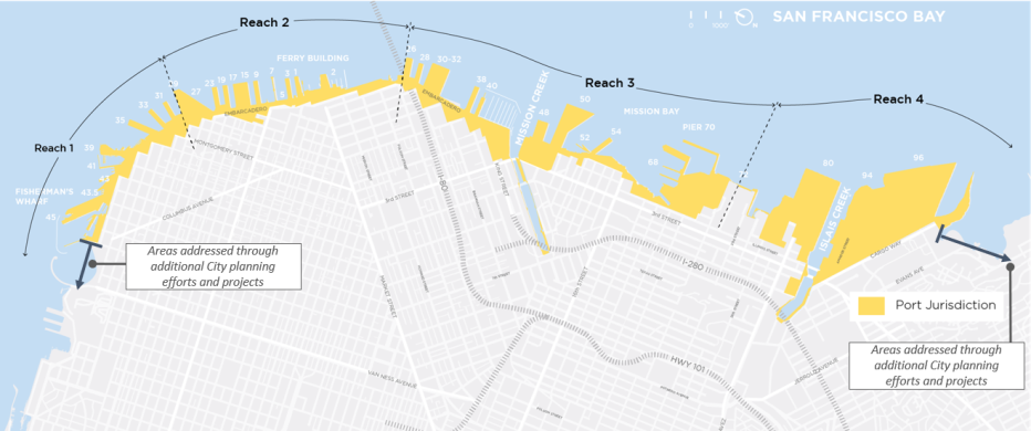
Port of San Francisco Jurisdiction Map - Waterfront Resiliency Program
Protecting the waterfront that protects so much
The Embarcadero waterfront supports historic piers, wharves and buildings, including the historic Ferry Building, all of which are central to the thriving Port. It also supports the Embarcadero Promenade that welcomes millions of people annually from all over the world and provides flood protection to San Francisco’s Financial District and other neighborhoods.
While the Embarcadero is the most well-known area of this waterfront, there is much more to this shoreline. South of the Embarcadero, the waterfront supports thriving communities, world class sports arenas and critical transit facilities - all pivotal to a flourishing, equitable city.
Serving as Program Manager, Jacobs is managing a team of over 30 subconsultants supporting the Port’s program including oversight of the seismic hazard risk assessment, flood assessment, development of the mitigation measures and support of the adaptation and envision planning horizons of 2080 and 2100. Phase I of the Seawall Program evaluates the applicability, effectiveness, risks and costs of the short and mid-term seismic reinforcements and flood mitigations along the waterfront.
The key assets along the seawall also serve critical emergency response and recovery functions, and it supports multiple municipal transportation systems and utility networks. The team are assessing and developing sustainable planning and design for the infrastructure to address the long-term resilience of the waterfront.
Several options being considered for shoreline seismic reliability, which can be implemented together or individually, may include:
- Ground improvements: improving the soil conditions on the landside of the Seawall, or through/beneath the seawall.
- Seawall replacement: construction of new Seawall segments, using modern seismic design.
- Structure improvements: strengthening or replacing bulkhead walls and wharves to withstand seismic movement.
- Utility relocation or replacement: relocating or replacing critical utilities that are currently protected by the Seawall.
Similarly, there are a range of approaches to reduce flood risk. These could include both “hard solutions” such as raised seawalls, gates, deployable barriers and “soft solutions” such as earthen berms and living shorelines or ecological seawalls.
A collaborative effort
A collaborative approach to the program is essential as our team engages with partner agencies to better understand potential impacts to intersecting infrastructure and assets along the Waterfront and partners with key organizations to secure funding.
The US Army Corps of Engineers in collaboration with the City of San Francisco, developed a first of its kind, San Francisco Waterfront Flood Study and Draft Plan for building a resilient shoreline by analyzing coastal flood risk and the effects of sea level rise (over the next 100 years) along the Port’s 7.5-mile jurisdiction.
Additionally, the collaborative team developed a comprehensive Multi-Hazard Risk Assessment (MHRA). It investigates a range of both earthquake and flood hazard scenarios and evaluates how those scenarios might cause damage and disrupt the transportation and utility infrastructure, buildings and marine structures along the Waterfront as well as affect the lives of the people who live, work and recreate along the Waterfront and shoreline.
Community at the core
Through public awareness and participation, community outreach serves as an integral part of delivering this program. With an equity team working closely with city and county agencies, an equity evaluation framework was developed to prioritize underserved communities, centering equity in the planning process and to inform future stages of the program.
Meet some of our team
-

Darren Milsom, Program Director
Darren serves as Program Director for the Port of San Francisco Waterfront Resilience Program working to transform the waterfront. Darren's 21-year career with Jacobs has brought him across the world, delivering programs that bring us toward a brighter, more resilient future.
-

Ramon Pérez Zaragoza, Deputy Program Manager & Engineering Lead
With more than 25 years of experience, Ramon has been involved in almost every kind of engineering there is, including roadway, marine and port, water and hydraulic, airport, railway and beyond. As Deputy Program Manager and Engineering Lead for the Waterfront Resilience Program, he’s been helping to manage this visionary program.
-

Anna James, Contracts Manager
Anna brings successful contracting relationships to the San Francisco Waterfront as Contracts Manager for the Waterfront Resilience Program. She ensures all our contracts and task orders are administered and executed allowing the program partners to focus on delivering the work.
-

Ann-Ariel Vecchio, Senior Resilience and Urban Planning Project Manager
Ann-Ariel's integrated planner experience spans 20+ years from merging flood resilience and nature-based solutions to urban design. She brings her passion for the environment, people and communities to programs like the Waterfront Resilience Program. Ann-Ariel leads our Waterfront Resilience Program Planning Team.
-

Vijay Kesavan, Resilience Planner
Vijay brings more than 13 years of expertise in leading cross-functional teams to advance climate resilience, equity and mobility initiatives. She serves as resilience planner for the Waterfront Resilience Program.
You might be interested in...
-
 News
NewsInfrastructure & Generating Enduring Social Legacy: 3 Complimentary Lessons Learned
Managed correctly, large scale infrastructure investment can create positive, long-term outcomes for historically disadvantaged and underinvested communities. Working closely with clients and their constituents around the world, Jacobs uses purpose-driven mechanisms to break generational barriers to upward mobility, minimize burdens, maximize community benefits, create education, training, and employment opportunities, and leave an enduring social legacy in the communities we serve.
-
 Showcase
Meet Ramon Pérez Zaragoza
When Ramon entered civil engineering school—or “Ingeniero de Caminos, Canales y Puertos”—in Valencia, Spain, he had no idea his natural affinity for challenges would take him around the world—from Africa to Costa Rica to San Francisco, and back again to Spain. Over his 25 years in the business, he’s been involved in almost every kind of engineering there is: roadway, marine/port, water and hydraulic, airport, railway and beyond.
-
 News
NewsMaturity Assessments, Preplanning and Introverted Leadership: A Q&A on Unlocking Program Management Success with Anna James
Building the inclusive, futureproof infrastructure of tomorrow requires closer client collaboration, tailored engagement and data-driven planning today. Project Manager and Group Lead Anna James defines the leadership and frameworks needed to succeed. Get to know Anna and her program experience in this Q&A.
-
 News
NewsNewly Released Multi-Hazard Risk Assessment Will Support Equitable Investment Decisions for Port of San Francisco
A Multi-Hazard Risk Assessment study evaluates seismic activity and coastal flooding and points to the need to continue to prepare for earthquakes as well as current and future flooding due to sea-level rise. Dive into the results and see what they mean for the Port of San Francisco’s approach to holistic resilience.
In the media
Port of San Francisco Waterfront Resilience Program: Waterfront Resilience Program
CIWEM and the Environment Agency, Flood & Coast Excellence Awards 2022: San Francisco Waterfront Resilience Program Highly Commended

How is the civil engineering sector building resilience, adaptation and carbon reduction into its projects? What are the implications for assets in the future?
In this podcast, Jacobs Program Manager Darren Milsom discusses how engineers can put resilience and adaptation at the heart of their designs. The discussion also highlights the importance of close collaboration with stakeholders to make complex plans workable, and how the sector is driving decarbonization while meeting the needs of communities.
Future Foundations.
Co-creating the world to come

From developing climate resilience and transitioning to a low-carbon future, to modernizing and transforming infrastructure, governments and businesses face critical challenges. How they respond will define our future.
As our clients navigate these challenges, we help them think differently – working together to pioneer tomorrow's infrastructure solutions and build the foundations for a prosperous, secure future.


