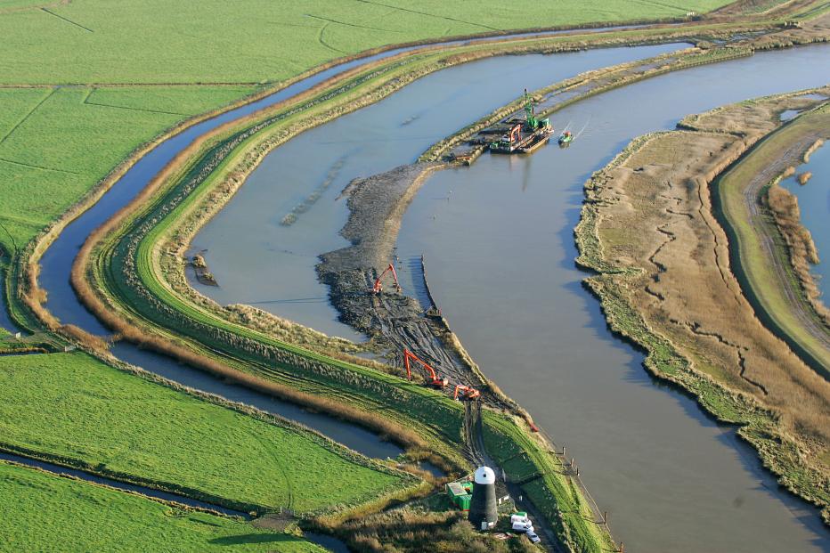
Aerial photography courtesy of Mike Page
Covering 30,000 hectares (ha) (74,141 acres (ac)) of environmentally and economically sensitive land in the east of England, this program has provided sustainable and affordable, long-term flood defenses for rural communities – ensuring the protection and improvement of habitat for rare and endangered species and protection for some of the most productive farmland in the U.K.
The £110 million ($150 million), outturn cost in 2021 £140M ($190M), contract was awarded as a Public Private Partnership (PPP) scheme by the Environment Agency in February 2001 to Jacobs as consultant and BAM Nuttall as contractor, working together in a joint venture as Broadland Environmental Services Ltd (BESL). The program’s main purpose was to provide a strategic approach to improving the Broadland flood defenses while engaging key stakeholders and the local community.
The program area is located wholly within the Norfolk Broads river system, an extensive area of wetland with a status equivalent to that of a National Park. Program focus is to improve and maintain the flood defenses along the tidal reaches of the Rivers Yare, Bure, Waveney and their tributaries in Norfolk and North Suffolk. As well as the 28 Sites of Special Scientific Interest (SSSI), the flood defenses protect 24,000ha (59,305ac) of agricultural land, 1,700 private properties, five previously undefended communities, rail and road infrastructure systems, important archaeological and built heritage structural remains, and several recreational facilities.
A strategic partnership approach for better outcomes
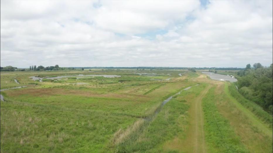
Construction of major improvement work was completed in 2017, with maintenance continuing to May 2021. The program has come to its 20th and final year of implementation, having achieved its objectives of protecting homes and farmland from flooding, while also protecting and improving habitat for rare and endangered species. Over 28 kilometers (km) (17 miles (mi)) of hard erosion protection mainly steel sheet piling has been replaced by wide reed beds through realigning (setting back) the flood bank to create more sustainable assets. This achieved a key project objective. These setback areas provide over 500,000 cubic meters for dredging disposal for the Broads Authority. Over 3 km (nearly 2 mi) of overhead electric cables are now underground, improving landscape and making the area safer for farmers and anglers. There are enhanced mooring facilities, improved navigation of channels and new slipways for boaters; new platforms for anglers, and 100 km (62 mi) of upgraded footpaths for everyone to enjoy the area.
The success of the Broadland Flood Alleviation Project demonstrates that large-scale improvement schemes that have a strategic approach to improving existing flood defenses can be accomplished within a nationally and internationally important wetland area. Long-term collaborative schemes that involve key stakeholder groups and landowners in detailed phases of public consultation can enable the development of partnership projects. These schemes achieve the desired objectives for biodiversity while reducing disturbance to important and notable sites.
-
30 K
hectares of land protected
-
1.7 K
properties, including 1,000 homes, protected
-
240 km
plus of flood banks upgraded with re-used and reclaimed materials
-
89.9 K+
tonnes of carbon designed out
Sustainable asset management
The total forecast expenditure at the end of the 20 years showed a total of 240 km have been improved and/or maintained at an outturn cost in 2021 of £140M ($190M) (approx. £600/m run of flood bank asset).
Program scope associated with sustaining the flood defenses in Broadland ranged from maintenance through emergency response to design, planning approval and improvement work. The core requirement was to sustain and strengthen the existing defenses taking account of sea level rise and settlement, to consider undefended communities, to resist breach and to provide an average and minimum residual life for the system.
Key to managing assets is having a detailed knowledge of their condition. Taking a slightly different approach to the Environment Agency’s AIM (Asset Info Management) system, we split the assets into three categories: flood banks (including earth embankments, flood walls, crest piling); erosion protection (steel/ timber piles, gabions, rip rap and reeded rivers edge); and fixed assets (flood gates/ boards, sluices and pumping stations). These were all inspected each year to understand how the assets were deteriorating making it easier to predict when we needed to intervene.
This ensured a timing intervention before an asset failed, making the cost of repairs significantly cheaper.
To meet the objective of moving to a sustainable flood defenses system, it was necessary to reduce the scale of unsustainable hard erosion protection assets, so the program actively pursued a preference for ‘soft’ bank options, rather than sheet piling. Where possible, we retired (set back) the line of the flood embankments away from the river’s edge. We have re-established reed covered fringes (known as ronds) along the rivers and, in doing so, reduced requirements for future maintenance. Some 75% of the steel sheet piling (22,500 tonnes) has been recovered, re-conditioned and re-used as frontage or anchor piles where a hard edge was the only option. Extraction of the piling at these locations has provided landscape benefits by eliminating the hard river edge and the canalized appearance and returning the river edges back to a more natural state.
By undertaking extensive geotechnical investigation and tailoring the design and construction of the improved and maintained flood banks to the locally available material, we saved the cost and impact of importing over nine million tonnes of clay soils. The use of 100% recycled plastic crest piling at some locations as opposed to more carbon intensive steel equivalents also enabled cheaper, faster and safer installation.
Asset management within a national park also presented unique challenges with its protected habitats. Best practice documents were produced to cover built heritage, public rights of way, navigation safety, tree clearance and mitigation for protected species, such as bats, otters, reptiles, rare and scarce plants and breeding birds. Extensive work was undertaken to mitigate damage to the water vole habitat and also to protect the water voles. Tagging and radio collars were fitted to a number of voles to understand better how they respond to displacement techniques required when undertaking, for example, vegetation clearance.
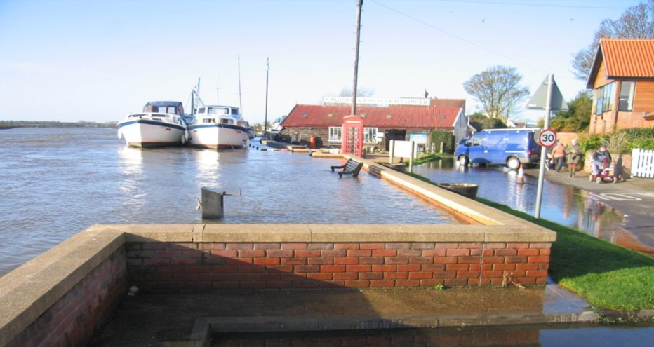
In December 2013, the East Coast of England was hit by the biggest surge tide since 1912, larger even than the great storm of 1953. As expected, the surge overtopped the flood banks temporarily flooding grazing marshes, and critically, the improved and maintained assets held firm protecting people, property and infrastructure with only superficial damage. This was a fabulous testament to the success of the scheme.
Visible evidence of the multiple benefits being generated by the program resulted in positive public feedback and has won over many who were wary at the outset of such a large program in such a sensitive area.
The Environment Agency/ BESL arrangement has delivered a complete flood risk asset management 'service', offering long-term predictability of costs in a time of economic uncertainty and great pressure on public finances. It has managed to deliver and maintain appropriate and sustainable flood defenses and achieved the best possible value for the U.K. taxpayer through closely engaging with local communities and partner organizations to deliver shared aims and objectives.
The program is an exemplar in delivering sustainable asset management, team working and collaboration, re-use of materials and resources, environmental responsibility, health and safety, and helping to address long-term economic requirements.
“The Broadland Flood Alleviation Project has been one of the largest engineering operations to have taken place in the Broads for many years. Looking back over the 20 years of the project there have been many successes. As well as strengthening the flood defenses for this very precious area, it has improved facilities for the public, including footpaths, moorings and fishing platforms. The new dykes behind the flood banks and the setback areas are proving to be the haven for wildlife that we all hoped for, and the landscape has benefited from the replacement of steel piling with soft engineering. But we should also acknowledge the very successful partnership between BESL and the Broads Authority, which has produced innovative solutions to the various challenges along the way, and provided sites for the disposal of dredged material from the rivers and broads, improving water quality and maintaining water depth for our boating community.”
Sustainability
The program has undertaken a substantial number of initiatives to ensure energy efficiency, enhance biodiversity, reduce emissions and minimize overall environmental impact.
The design philosophy has sought to minimize the environmental impact of strengthening the flood banks, through sourcing and using material extensively from the adjacent new soke dyke. This ensured less than 5% of the total material used on the scheme was imported. The design and construction of the new soke dykes maximized biodiversity.
Reusing site materials
The project team soon realized the opportunities for materials reuse. A pile handling yard was set up for the treatment of all removed piles. All recyclable materials, such as steel and timber piles, were cleaned and trimmed before being stock piled for re-use. The processing of these piles employed biosecurity measures to prevent the spread of killer shrimps, an invasive species presenting a serious threat to local marine biodiversity. Designs were then tailored to maximize the use of these materials – shortened piles were used as anchor piles, and timber was either used in erosion protection systems or, more innovatively, by a local craftsman to create bespoke furniture. In this way we achieved near zero waste.
How does the program actively enhance, create and protect the local natural environment?
The program area lies within the most important and sensitive wetland complexes in Britain. Consequently, consideration of how the natural environment should be protected and enhanced is a key aspect of scheme development.
Examples of how the natural environment has been protected and enhanced include:
- Constructing one of the largest reptile banks and hibernacula in order to provide a receptor site for hundreds of adders and lizards whilst construction work was undertaken.
- Innovative mitigation techniques, endorsed by Natural England, developed for water voles, including two academic papers on water vole mitigation.
- Seeds from rare plants were collected and new plants grown so that they could be re-introduced on completion of the construction works.
- New soke dykes incorporated berms (ledges) that provided a substrate for reed, sedges and other plants to colonize.
- The construction of new setback banks and subsequent removal of the old bank and redundant piling created new open water lagoon and reedbed habitats that are used by a wide variety of species, including marsh harriers.
- Bird and bat boxes plus artificial otter holts were constructed using timber and brash from pre-work vegetation clearance.
- The flood banks provide protection to large areas of agricultural marshland, which itself has significant biodiversity value for breeding and wintering birds, aquatic plants and invertebrates.
What social and economic benefits have resulted for the local community?
One of the major benefits of the long-term nature of the program is the external and partner organizations’ confidence in BESL’s program of ongoing work enabling them to make strategic decisions wholly aligned with the program. The Broads Authority based a significant portion of both its mooring and sediment (dredging) disposal strategy around BESL’s delivery plans, saving the organization money and benefitting all river users in the area.
Facilitating local community enhancements was central to the program. Flood defense work was welcomed by most and seeing this long-term investment in the area had a real benefit for local people and communities. The long-term security promoted private investment and, where possible, the team encouraged and assisted in delivering several enhancements which improved local amenities, recreation opportunities and health and well-being initiatives. BESL’s work with EDF Energy, for example, resulted in over 2 km of overhead electric cables being placed underground, reducing bird strikes, angling risks, enhancing the visual landscape and improving safety, not only for the construction team, but also local farmers.
Future of Broadland Initiative
Looking to the future of the Broads area, the Broadland Future Initiative (BFI) is a partnership to develop the future flood risk management plan to address climate change and rising sea levels over the next 100 years or more, putting people at the heart of decision making. The plan will cover the Norfolk and Suffolk Broads, the Eccles to Winterton frontage and Great Yarmouth.
BFI has been set up by organizations responsible for managing flood risk, including The Environment Agency, Natural England, County and District Councils, Internal Drainage Boards, Broads Authority, National Farmers Union, Water Resources East, the Royal Society for the Protection of Birds (RSPB) and the Wildlife Trusts, who will work together in developing the plan.
The project is divided in phases. The first phase is a baseline-data exercise and aims at defining the problem and setting the objectives. It will produce a number of technical and public-facing documents for stakeholder consultation and will also determine requirements for any new hydraulic modelling for the strategy. The second phase will include the modelling activities and the strategy development activities.
Jacobs is partnering with the Environment Agency to deliver BFI, supporting as design lead in the North-West and Eastern England Collaborative Delivery Teams.
Awards
The project has won numerous accolades throughout the years, including:
- Nominated for ICE People’s Choice Award, 2019
- Institute of Collaborative Working- Environmental Enhancement Collaboration Award, 2018
- ICE Exceptional Merit Award, 2017
- Norfolk Biodiversity Partnership Community Biodiversity Business Award 2013
- Environment Agency Project Excellence Award 2013-Cantley Staithe
- Environment Award at British Construction Industry Awards, 2011
- Broadland District Council Design Award for the Reedham Quay Flood Defences, 2003 Finalist IEEM Best Pratice Award, 2011
- Campaign for Protection of Rural England, Norfolk Award, 2009 for works at Cantley Marshes
- Contract Journal PPP/PFI Award, 2005
- Engineering Education Scheme Award
- Twice awarded Considerate Constructors Scheme, Silver
- Four times winner of Gold Award – Royal Society for Prevention of Accidents


