We’re living in the era of digital disruption and we need bold digital and technology leadership now more than ever before. Leading this change demands knowledge, imagination, new thinking, an appetite to reinvent and the courage to challenge conventions.
In this series, we're celebrating our team of digital and technology experts and visionaries, spearheading the development and delivery of our technology-forward solutions for smarter working, and better living in Asia Pacific and the Middle East.
For this feature, we caught up with Ben Vordermaier, our section lead for data capture in the Australia and New Zealand (ANZ) region, to better understand the field of data capture, its importance, usage scenarios, emergent trends and how digital technologies have transformed this field over the years.
Let's get to know Ben:
Hi Ben! Tell us a bit about your career background and role at Jacobs.
I studied a Bachelor of Geoinformatics and Surveying at the University of South Australia. Upon graduating, I started my career as a surveyor at a small engineering survey business in Adelaide focused on construction set out and engineering surveys. As I progressed in my early career years, I was exposed to larger and more complex construction projects. While in Adelaide, I was lucky enough to work on some landmark projects like the Adelaide Oval and Adelaide Convention Centre redevelopments, focusing on the areas of steel and concrete construction. I moved to Melbourne in 2014 and took on a role with Jacobs as a senior surveyor in 2016.
Since starting with Jacobs, I’ve worked on a vast array of projects across all sectors and in several different capacities, initially as a surveyor, then taking on survey lead roles on major design projects and project manager roles for small to medium survey projects. In 2018 I took on the Melbourne survey team lead role before being appointed as the ANZ data capture section lead in 2020. My current role is much more focused on people leadership, business management, risk management and helping to guide the strategic direction of the data capture business in ANZ. I’m still very involved in project management and delivery, business development and proposal responses.
What is data capture, why is it so important, and what are its typical usage scenarios?
The data capture section in ANZ is made up primarily of surveyors and photogrammetrists. We capture site information via our suite of tools to input into the project's design, engineering, analysis and decision-making process. This site information may include, but is not limited to, aerial imagery and Light Detection and Ranging (LiDAR), 3D laser scanning and modeling, detailed feature survey and terrain models and underground utility investigations.
We also manage survey and utilities data as it flows through the project planning, design and construction phases. In recent years, we’ve been utilizing our data capture and analysis tools to support operation and maintenance programs.
As survey professionals, we understand what data capture techniques and data outputs suit various project phases. Not only can we capture the appropriate information, but we also manage risk by understanding and reviewing what data is available and providing technical advice on its suitability for the project at hand.
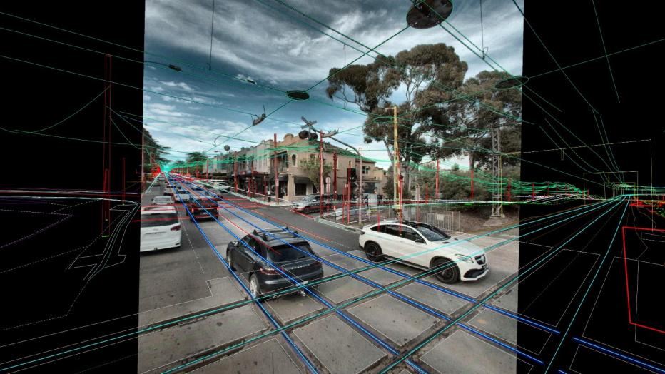
3D survey data overlayed with captured street imagery
From the time you began your career to the rapid digitizing of data capture that’s underway today, how has this field transformed over the years?
Surveying as a profession is not a new one. We’ve existed since ancient times as far back as building the pyramids. Over the years, survey and data capture tools and processes have come a long way, from field teams operating a theodolite to robotic total stations and now mass data capture via mobile and static 3D laser scanners and remote piloted aircraft or drones (RPAs).
These new tools are opportunely handy and are changing how we deliver projects. At the same time, they are becoming a lot easier to use and more accessible from a cost perspective, opening the door for many more competitors in the space where Jacobs as an early adopter has been leading the market. However, the fundamentals of survey capture remain the same. Our years of project experience have allowed us to stay competitive and step into a higher-value role as we understand “good” data. It has been great to see these technology advancements become standard solutions for delivering projects and seeing project teams and clients starting to utilize the vast amount of valuable data we provide.
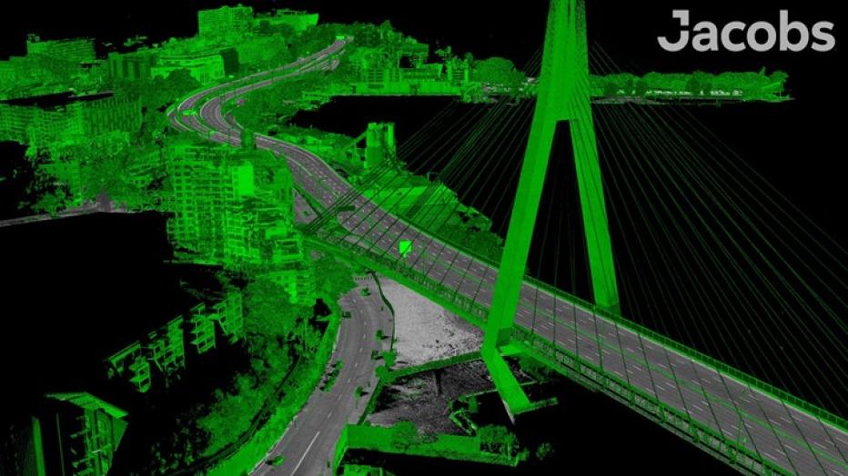
3D point cloud data from one of our Mobile Laser Scanning projects
“Capture tools are becoming easier to use and cheaper to access. Our value as surveyors comes by adding a level of professionalism and understanding to the outputs from these tools and maximizing the value of the data. As automation through artificial intelligence and machine learning expands, key inputs will be reliable data to ensure quality results. Understanding what‘s possible adds real value to solving our clients’ challenges.”
Data solutions are central to Jacobs’ new strategy. How do innovative data capture technologies aid geospatial processing, analysis and visualization?
We can now rapidly capture vast amounts of accurate 3D and imagery data. Historically, we’ve simplified these datasets to produce the traditional survey outputs for engineering and design. Now and into the future, we see this data playing a more significant role in project delivery, operations and maintenance. We’re using 3D point clouds to perform design reviews and visually inspect how a proposed design looks, interacts with the environment, and impacts existing features. We’re undertaking clash detection processes against existing underground assets and new designs. We use automated tools and machine learning algorithms to identify pavement cracks and rutting. We also use our data to identify clearance infringements in rail corridors and plan maintenance programs for vegetation and ballast remediation. These are a few examples of how our innovative data capture tools and expertise in collaboration with our engineering and data science teams allow us to extract more value from the data we capture to inform better decision-making faster than ever.
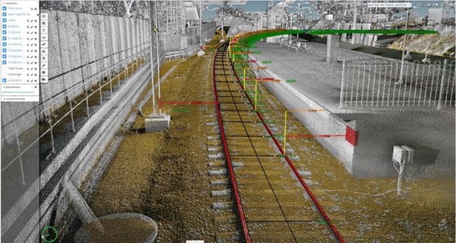
Data analysis of some 3D Pointcloud data
Looking toward the future, what are some emergent trends in geospatial data capture that budding surveyor must keep an eye out for?
Capture tools are becoming easier to use and cheaper to access. Our value as surveyors comes by adding a level of professionalism and understanding to the outputs from these tools and maximizing the value of the data. As automation through artificial intelligence and machine learning expands, key inputs will be reliable data to ensure quality results. Understanding what’s possible adds real value to solving our clients’ challenges.
Tell us about a memorable project you’ve been involved in and why it’s special to you.
I’ve been lucky enough to work on exciting projects throughout my career in the construction and engineering sectors. One of the most memorable was working directly with the structural steel contractor building and erecting the new roof structure for the Adelaide Oval redevelopment project. Throughout this project, I worked across the factory and site to check bolt hole alignments while manufacturing the truss and roof pieces. I then undertook set out and alignment on site to ensure all the pieces of this very complex structure fit together without an issue.
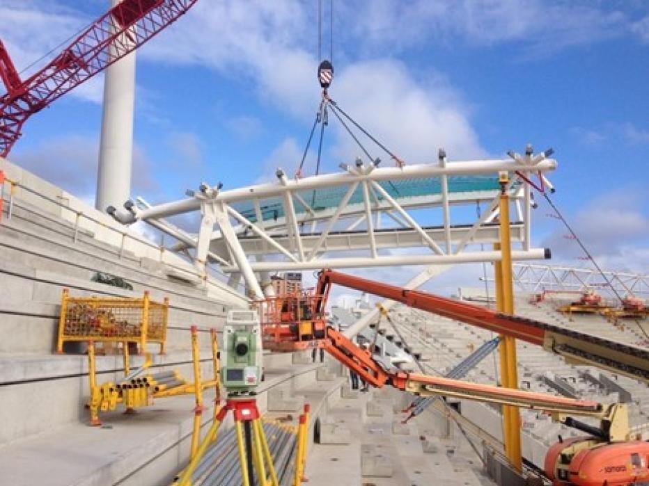
Onsite installation monitoring of the first Truss of the Adelaide oval eastern grandstand roof
What advice would you give to young geospatial professionals?
Some great advice I got when I was finishing my degree was never to stop learning, and I think that holds true today. The trick in this day and age where everyone is so “busy” is to find the headroom to learn and develop and do something new. My advice for people struggling to find that time is to learn their craft and then transfer that knowledge to others, allowing people to share the project delivery load and to look for the next learning opportunity. The next bit of advice would be to show initiative and be proactive. If you see something that needs to be done or improved, don’t wait to be asked or told, take the opportunities in front of you, talk to your line manager and get into it.
If you aren’t in the office, what would we most likely find you doing?
Outside of work, I’m kept busy by my 11-year-old son and 2-year-old daughter, the family dog and my partner as we are slowly renovating our home. I enjoy playing basketball to stay fit, traveling when we get the chance and enjoying the outdoors and new experiences with friends and family. And there is always time for a cold beer in the afternoon when the jobs around the house are done.
People would be surprised to know that …
Back in University, my friend and I qualified to play European Handball at the World University Games. We didn’t really know how to play the game, but we had a lot of fun and scored a trip to Venice in Italy.
What do you enjoy most being part of #OurJacobs team?
For me, it’s the people and the culture. Having moved to a new city in 2014 with very few local connections, it was great coming into Jacobs and meeting teams of new friendly faces from various technical and cultural backgrounds. Everyone is very inclusive and collaborative, making Jacobs a great place to work, and I have been lucky enough to build some great, long-lasting friendships with my Jacobs team.
About the interviewee

Ben Vordermaier is an experienced surveyor currently working as the section leader of the Jacobs ANZ data capture group, which includes land survey and photogrammetry professionals. Ben has over 14 years of experience across the survey industry's construction, engineering and consulting disciplines. Throughout his career, he’s worked collaboratively with engineering and construction staff to deliver projects in multiple fields, including commercial construction, land development, civil infrastructure, water infrastructure, mining, power and energy. With a strong focus on positive communication, Ben is driven to understand client challenges and needs, to deliver optimal outcomes for their projects. With his recent move to people leadership, Ben is committed to building a high-performing group with a positive and inclusive team culture, where people feel empowered to develop, succeed and exceed their career aspirations.
You might be interested in...
-
 News
NewsJacobs Announces New Strategy - Boldly Moving Forward
Jacobs today announced its new three year strategy, including a comprehensive video from Jacobs' Chair and CEO Steve Demetriou, President and CFO Kevin Berryman, President and COO Bob Pragada, Chief People & Inclusion Officer Shelie Gustafson and other leaders across Jacobs. The video and accompanying materials are available at invest.jacobs.com.
-

 News
NewsBeyond data: Mining for more than meaning
We sat down with Senior Director & Data Scientist Dr. Jennifer Blum; Michael Brown, our global technology lead for predictive analytics; and Director of Predictive Analytics David Morgareidge to discuss data visualization, advancements in data analytics and how our data scientists are contextualizing data to help clients make smart decisions.
-
 News
NewsJacobs and Palantir Launch Global Strategic Partnership for Data Solutions
Jacobs (NYSE:J) and Palantir Technologies Inc. ("Palantir," NYSE: PLTR) today announced a global strategic collaboration targeting data and technology solutions for the infrastructure and national security markets.
-
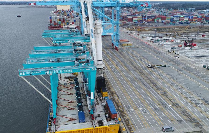
 News
NewsHow Drones Are Guiding Major Construction at U.S. Ports
Drone technology is constantly evolving and achieving countless business benefits, including bringing an estimated additional $82 billion and a 100,000 job boost to the U.S. economy by 2025. What if we showed you how drones took flight to guide Jacobs and the Port of Virginia's construction progress on a major expansion to double capacity?
Join #OurJacobs team
What drives you drives us as we work to build a better world – together. At Jacobs, every day is an opportunity to make the world better, more connected, more sustainable. We’re always looking for dynamic and engaged people to join our team. Bring your passion, your ingenuity and your vision.
