We’re living in the era of digital disruption and we need bold digital and technology leadership now more than ever before. Leading this change demands knowledge, imagination, new thinking, an appetite to reinvent and the courage to challenge conventions.
In this series, we're celebrating our team of digital and technology experts and visionaries spearheading the development and delivery of our technology-forward solutions for smarter working, and better living in Asia Pacific and the Middle East.
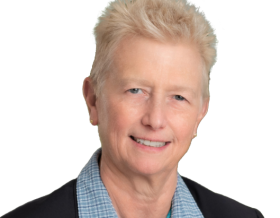
For this feature, we caught up with Paul Digney, our technical director of data capture for the Australia and New Zealand (ANZ) region, to talk about innovative digital technologies that enhance data capture, the role of spatial data in tackling global challenges and his experience as the president of the Surveying & Spatial Sciences Institute (SSSI) Australia.
Let's get to know Paul:
Tell us about your role at Jacobs, and what’s your favorite part of your role?
I’m the Technical Director for Data Capture at Jacobs, working across Australia and New Zealand, Asia and the Middle East. My role has multiple elements, working with operations to ensure we provide the best solutions to our clients while also providing individuals with the right skills and experience. I also support sales to position data capture capabilities – as digital solutions are at the core of our integrated offerings and a crucial part of our collective value proposition.
My favorite part of the role is working with many talented people within the digital solutions team and other parts of the organization. A large part of my job is connecting, communicating and networking. I am constantly engaging with people, sharing knowledge, challenging thinking, providing advice and leveraging my experience, relationships, and the broader capabilities of the data capture team to drive better outcomes for our clients.
You are also the current President of the Surveying & Spatial Sciences Institute. Tell us a bit about the organization and how has this experience enriched your career?
Yes, I am now well into my second year as president of the SSSI. SSSI is Australia's peak professional body representing the multitude of professions within the surveying and geospatial information sciences. SSSI has currently over 2000 members nationally, and what sets it apart is its unique national reach, which enables many significant strengths: informed advocacy, the ability to break down geographic silos and build technical excellence, the ability to offer a plethora of events that promote a diverse network of professionals to network and collaborate, promote certification to strengthen the skills and knowledge of the Australian geospatial and surveying industry, provide professional development opportunities, migration skills assessment and lot more.
I have been involved in SSSI and its legacy organizations for well over two decades now. I was always encouraged to become active within the broader surveying industry early in my career. Engaging with a professional or industry association provides several advantages. It helps develop and grow your knowledge outside of your immediate workplace, builds a network with peers and others within the industry, and helps establish your brand and recognize your contribution over time.
The value of my participation with SSSI has undoubtedly grown in recent years. Having joined the SSSI board in 2018, I've had the opportunity to learn and develop skills and gain experience relating to the responsibilities of a company director. I could also build and grow relationships with a broad range of industry leaders across all sectors, from government, academia, and private industry— each offering new and valuable insights into the challenges and opportunities the geospatial industry has to offer.
As president, I have taken on additional responsibility. I am currently leading a process of reform for SSSI, where we are critically assessing the role and value of a professional association in a rapidly transforming society. The needs of our members and the sector are continually evolving due to the rapid development of technology, the evolving way information is shared and accessed, and a range of other growing disruptions to our current traditional model.
Through my contribution and engagement with SSSI, I have developed a much greater awareness of the field's value and the vital role it plays in nearly every aspect of our society. More importantly, it has shaped and aided my career in my choices over the last 30 years.
“Geospatial technologies enable information to be integrated and help support better decision making, scenario testing, unlocking, and visualizing insight. Overlaying environmental, social, infrastructure, and economic datasets to explore a problem space helps realize sustainable, resilient and equitable development opportunities.”
What are some of the new innovative digital technologies that can enhance data capture?
Technology is a critical component of data capture (surveying) and continues to drive innovation in various ways. There are exciting developments in several areas, including drone technology – the surveying industry has seen significant growth in drone-related technology. By using these unmanned aerial vehicles (UAVs), surveyors can now conduct their day-to-day tasks with relative ease and increased efficiency and gather helpful information for future consideration. Additionally, the technology has allowed surveyors to inspect areas that have previously been deemed unsafe for access, reducing the risk of personal injury and providing a cost-effective solution to a previously time-consuming task.
Other significant innovations that continue to have a substantial impact and provide value are using and applying artificial intelligence (AI) and augmented reality (AR). These technologies benefit several areas, like Building Information Modelling (BIM), which involves creating a comprehensive digital description and working collaboratively throughout each project stage. These precise 3D models, or digital twins – contain a wealth of data relating to every physical and functional element of the build. With AI, the ability to incorporate machine learning with human intelligence qualities has already begun to infiltrate these systems. For instance, analyzing large quantities of data has several practical applications for quality control assessments. AI can optimize the process and effectively account for any logistical issues well in advance by utilizing theoretical techniques, resulting in significant savings once the project finally reaches the building phase. When it comes to data capture, the combination of AI and BIM has several important implications. One of them is accessing a shared 3D visualization of the site, which helps analyze and control the process. What’s more, combining 3D visualizations with AR can also provide a realistic rendering of a building or space before its actual construction. A practice that can be especially beneficial to those assessing future developments or cases where specific repair works have been proposed but not completed.
Can you share some examples of how Jacobs is leveraging spatial data to tackle some of our global challenges?
Jacobs' PlanBeyond 2.0 sustainable business strategy aligns our key business objectives with those United Nations Sustainable Development Goals (SDGs) that are most relevant to our business. It defines our aspirations for how we, as an organization and as individuals, can each play a part in creating a sustainable future for all.
In achieving these objectives, the role of spatial data in supporting activities to advance sustainability is critical and, in many ways, underpins every solution and activity Jacobs undertakes. The United Nations has also recognized the importance of spatial data documented in its Transforming our world: the 2030 Agenda for Sustainable Development, which spells out the appropriate use of geospatial and Earth observation data for measuring, monitoring, reporting, and achieving the SDGs.
An example would be the role of Jacobs geospatial teams globally, helping to build and develop sustainable cities and communities. Geospatial technologies enable information to be integrated and help support better decision-making, scenario testing, unlocking, and visualizing insight. Overlaying environmental, social, infrastructure, and economic datasets to explore a problem space helps realize sustainable, resilient and equitable development opportunities.
What advice would you give to young geospatial professionals?
From my experience of over 30 years working in the geospatial industry, my main advice would be to continue investing in your education. Our sector is one of continual transformational development and maintaining your knowledge and relevant experience is critical in the changing world. No one expects you to have it all figured out as a young professional, and success doesn’t come overnight. Actively listen, be a sponge and soak up as much knowledge and experience as you can to nourish and grow your career in time.
The other sage advice would be to network, network and network. I would encourage those starting their career to build a strong network and engage with their peers and colleagues. Find a few mentors and sponsors to coach you and advocate for you.
Most interesting career moment?
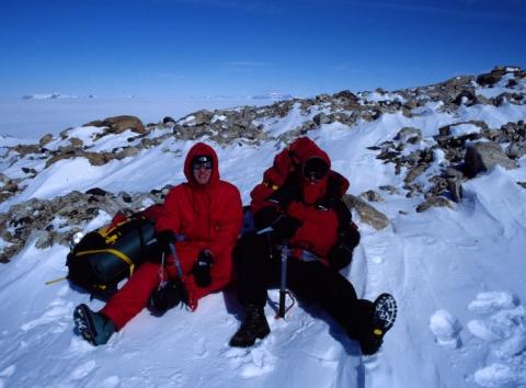
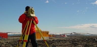
I have been very privileged to have many rewarding career highlights. Overall, the main highlight has been traveling and visiting some fantastic locations. Work took me to Antarctica, where I was fortunate to spend three summers undertaking a range of surveying and geospatial work in the Australian Antarctic Territory. I also spent four incredible days surveying the remote Sub-Antarctic Heard Island, which has the little-known title of the tallest mountain in the Australian-owned territory – Big Ben which stands at 2,745 meters (over 9,000 feet) and has an active volcano. Other remarkable locations I have visited include six months of surveying in the PNG Southern Highlands and the Cocos (Keeling) Islands, another remote territory of Australia located in the Indian Ocean comprising two coral atolls and an additional 27 tiny islands. The highlight was the survey work undertaken on the isolated North keeling island, which is uninhabitable and has a fantastic colony of seabirds and other exotic wildlife.
If you aren’t in the office, what would we most likely find you doing?
I have a young family with two small girls at home, which takes up a lot of my time away from the office. I recently built a new home, so if I am not at the park with the kids or helping them ride their bikes, you will find me in the backyard building or gardening. I hope to have all the work done in the not-too-distant future and spend more of my time relaxing and enjoying the fruits of all the hard labor.
People would be surprised to know that …
I doubt I could adequately surprise people with something they don’t know about me. I tend to be very much an open book and willing to talk about pretty much anything and everything. Perhaps one interesting mention would be that I am desperate to pour the perfect cup of coffee. I would be perfectly happy being a full-time barista in another life.
As a passionate Tasmanian, tell us three lesser-known facts of the island state.
- Tasmania isn't as small as you think. It's about the same size as Ireland or Sri Lanka, and our coastline measures about 4,500kilometers (close to2,800 miles) – that's longer than the combined coastlines of NSW and Victoria.
- Almost half (42%) of the state is either World Heritage Area, national park, or marine and forest reserve.
- Many people consider Tassie a wet, cold place, but Hobart, where I live, is Australia's second-driest City behind Adelaide.
What do you enjoy most about being part of #OurJacobs?
The most important thing about being part of Jacobs is the people. In over 15 years here, I have met some wonderful, caring, and amazingly talented people, many of whom I continue to work with, and I have formed lifelong friendships with them. I also enjoy the challenges of my role and being part of the Jacobs family. There are innumerable opportunities to learn and help solve real-world problems every day – it is hard to imagine another company that offers Jacobs' extraordinary scale and depth of opportunity.
About the interviewee
Paul Digney is an experienced surveyor and spatial services consultant who works across the Australia & New Zealand region as Jacobs' Survey Technical Director providing technical advice and support across diverse areas. Paul has over 25 years of experience in the surveying/spatial profession with experiences as a surveyor and project manager, providing specialist consultancy services in 3D laser scanning and associated 3D spatial technologies to the resources, manufacturing, Engineering, and Architectural sectors in Australia and internationally. With the growth of digital engineering and BIM practices within the design sectors, Paul has driven consultancy practices that provide spatial solutions for clients to support their business needs with confidence. Given his relevant experience in both the public and private domain, Paul is a trusted consultant and has developed strong working relationships across various industry sectors. His experience, personality, and communication style enable him to be an effective conduit between clients and technical solutions.
You might be interested in...
-
 News
NewsThe Criticality of Effective Program Management in the Digital Age: A Q&A with Ian Sharpe
For this feature, we caught up with Ian Sharpe, our technical director for program advisory in Australia and New Zealand, to understand the importance of program management, how it helps manage multiple projects and interdependencies effectively, and the role digital technologies play in successful program delivery.
-
 News
NewsQ&A: Talking with OhSung Kwan, Digital Engineering Lead
For this feature we caught up with Digital Engineering Lead OhSung Kwan who has won accolades from clients, contractors and vendors and has now been invited by the industry think tanks to look into digitalization in the industry. OhSung talks about the relevance of Building Information Modelling and its benefits.
-

 Podcasts
Digital Twins: The Imagery of Imitation
A new kind of twin is emerging on the landscape and helping to shape the cities of tomorrow. Called digital twins, these technological marvels seek to create extremely accurate virtual replicas of objects in the real world. And the application of digital twin technology is finding its way into a variety of sectors, including healthcare and manufacturing. In this episode of If/When, we discuss digital twins with Dr. Jonathan Reichental, founder and CEO of Human Future and Dr. Raja Kadiyala, Jacobs Global Digital Market Director.
-
 News
NewsQ&A: Talking with Tara Yates, Head of Digital Partnerships, APAC
We connected with our Head of Digital Partnerships for APAC, Tara Yates to talk about her passion for racing cars, being a model for 12 years and why digital solutions are crucial to shaping our future.
Join #OurJacobs team
What drives you drives us as we work to build a better world – together. At Jacobs, every day is an opportunity to make the world better, more connected, more sustainable.
We’re always looking for dynamic and engaged people to join our team. Bring your passion, your ingenuity and your vision.
